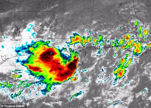
A massive tropical rainstorm that already soaked Florida and Louisiana is changing course — and it’s now taking aim at the heart of America.
Meteorologists warn that the system, still unnamed but increasingly dangerous, could unleash devastating flash floods across 11 states, stretching from the Gulf Coast all the way to Pennsylvania and Ohio by early next week.
🔴 More than 30 million people are in the storm’s potential path, with cities like Chicago, Cincinnati, Pittsburgh, Indianapolis, and St. Louis bracing for impact.
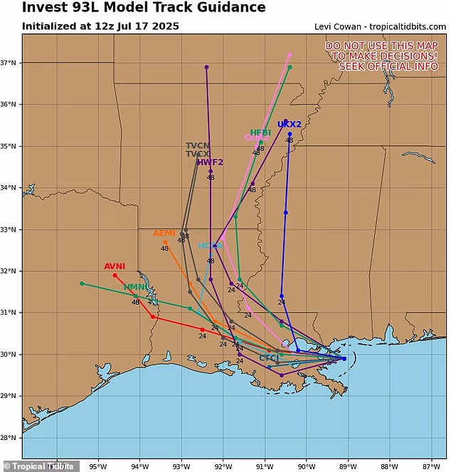
The storm, dubbed Invest 93L, was originally expected to threaten the East Coast — but the latest spaghetti models show a dramatic shift. Now, it’s projected to plow through Louisiana and Arkansas, reaching Illinois, Iowa, Indiana, Ohio, and Pennsylvania by Monday.
⚠️ Flash Flood Emergency in the Making
“We’re increasingly concerned,” said AccuWeather’s lead hurricane expert Alex DaSilva. “Moisture from this storm is surging northward, and the flooding risk is real.”
Rainfall totals of up to 8 inches are possible in parts of Louisiana, with 4 to 8 inches forecast for Iowa to the Ohio Valley. In areas with already saturated ground, even moderate rainfall could spark landslides, road collapses, and catastrophic flooding.
The storm has not yet reached hurricane status — it would be named “Dexter” if it strengthens — but its impact is already being felt and could intensify fast.
🚨 Flash Floods Already Claiming Lives in 2025
AccuWeather’s chief meteorologist Jonathan Porter called 2025 “a tremendously dangerous year” for flash floods. So far, flash flood reports are up 70% compared to the 10-year average.
“We’ve seen tragedies from coast to coast,” Porter warned.
Just two weeks ago, a flash flood killed at least 134 people in Texas Hill Country, with nearly 100 still missing. In New York City, subway riders were left wading through sewage water after underground stations flooded during a July 14 deluge.
📉 Soaked Ground + More Rain = Disaster
Experts say the storm’s path cuts directly through regions already hammered by recent rainfall. That means the soil can’t absorb any more water, increasing the chance of severe runoff, flash flooding, and structural damage to bridges, roads, and buildings.
“People in low-lying areas, near creeks, rivers, and campgrounds should prepare to evacuate at a moment’s notice,” Porter said.
Rainfall rates could reach 1 to 3 inches per hour, with life-threatening flooding possible through early next week.
🔄 What Are Spaghetti Models — and Why They Matter Now
If you’ve seen the colorful storm lines spreading across social media, those are spaghetti models — maps that use multiple forecasting programs to predict potential storm paths.
Meteorologist Levi Cowan, founder of Tropical Tidbits, says these models are updated frequently and used by top agencies like NOAA and the European Centre for Medium-Range Weather Forecasts.
The tighter the lines, the higher the confidence. And right now, those lines are pointing straight into America’s heartland.
🌀 And It’s Not Over — More Storms Brewing
Even as this system barrels north, new tropical developments are brewing, according to AccuWeather. A second system could begin forming over the Gulf of America (formerly the Gulf of Mexico) starting Monday, July 21.
The National Oceanic and Atmospheric Administration (NOAA) predicts up to 19 named storms, including 10 hurricanes and 5 major hurricanes this season — all above average.