More than 400 small earthquakes shook Washington’s Mount Rainier within just 12 hours on Tuesday, reigniting concerns that one of America’s most dangerous volcanoes may be inching closer to a catastrophic eruption.
The swarm of seismic activity prompted an urgent update from the U.S. Geological Survey (USGS) at 1:00 p.m. PT, which emphasized a sobering reminder: Mount Rainier is not extinct — it’s very much alive.
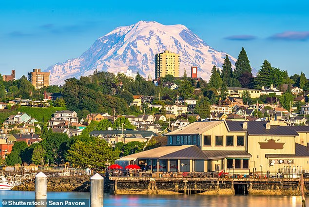
Towering at 14,411 feet, this massive stratovolcano dominates the skyline for nearly 90,000 residents across the Pacific Northwest, including cities like Seattle, Tacoma, Yakima, and even Portland, Oregon. Though Mount Rainier hasn’t erupted in over a millennium, the frequency and intensity of Tuesday’s quakes caught the attention of volcanologists, given that such swarms are often linked to volcanic unrest.
Despite the flurry of activity, geophysicists are urging calm — for now. USGS scientist Alex Iezzi explained that these tremors likely aren’t being triggered by rising magma, but rather by hot water circulating beneath the surface. These superheated fluids can move through ancient rock fractures and fault lines, causing minor yet frequent quakes as pressure builds and releases.
“These events are being driven by fluid movement,” Iezzi said. “It’s a dynamic hydrothermal system, not necessarily a sign that magma is on the move — but it’s something we take seriously.”
The strongest of Tuesday’s quakes barely registered at magnitude 2.3, while most were below 1.6 — too small to be felt by humans. But their sheer number — over 400 in a single half-day — marks the most intense swarm since 2009, when Rainier experienced over 1,000 tremors in a short period.
Mount Rainier typically sees only about nine earthquakes per month, and while it has a history of periodic swarms every one to two years, the size and concentration of this latest sequence has renewed focus on the long-dormant volcano’s potential for devastation.
“Mount Rainier keeps me up at night,” said volcanologist Jess Phoenix, a science communicator and advisor to the Union of Concerned Scientists. “Because if it goes, the consequences could be apocalyptic for the region.”
Despite the alarming uptick in seismic activity, the USGS maintained its alert level for Rainier at “GREEN / NORMAL,” noting that current conditions fall within the range of background activity.
That said, Rainier remains one of the most closely monitored volcanoes in North America. A sophisticated network of instruments — including seismometers, GPS units, infrasound sensors, and live webcams — track its every move, ready to alert authorities to the slightest change.
“There’s currently no sign of ground deformation or unusual gas emissions,” the USGS stated, “and no anomalies have been observed on infrasound monitoring stations.”
Yet experts stress that the real threat from Mount Rainier isn’t lava or explosive ash columns — it’s lahars.
A Silent Killer: The Lahar Threat
If Mount Rainier erupts, it likely won’t be the lava that devastates nearby towns. It will be lahars — powerful, cement-like mudflows made from melted snow, volcanic rock, and debris — capable of traveling at freeway speeds, crushing everything in their path.
“Tacoma and South Seattle are literally built on ancient lahars,” Phoenix said. “Massive, 100-foot-thick flows of mud and debris from Rainier’s past eruptions.”
These monstrous torrents can form not only from eruptions but also from slope failures caused by heavy rainfall or gradual geological weakening. Once triggered, they can travel dozens of miles, destroying roads, homes, and infrastructure, often with little warning.
Scientists reference the catastrophic 1985 eruption of Colombia’s Nevado del Ruiz volcano as a grim warning. That eruption unleashed a sudden lahar that wiped out the town of Armero, killing over 25,000 people in just a few hours. It remains one of the deadliest volcanic disasters in recorded history.
Even closer to home, the 1980 eruption of Mount St. Helens — just 50 miles from Rainier — produced a destructive lahar that annihilated more than 200 homes and took dozens of lives.
These past events have profoundly shaped how scientists and emergency officials view the threat of lahars in the Pacific Northwest. In fact, portions of western Washington have been designated as “Volcanic Hazard Zones,” where evacuation plans are constantly revised and rehearsed.
Prepared, But Not Immune
While Tuesday’s quake swarm doesn’t signal an imminent eruption, volcanologists and emergency planners say it’s a wake-up call.
“It’s not a matter of if, but when Mount Rainier will erupt again,” Phoenix emphasized. “And when it does, the consequences will depend on how prepared we are.”
The USGS and the Pacific Northwest Seismic Network will continue to monitor Rainier around the clock, while residents are urged to stay informed, review emergency plans, and not dismiss small quakes as meaningless.
In a region already prone to earthquakes, tsunamis, and floods, Mount Rainier serves as a towering reminder that the Pacific Northwest sits on a geological powder keg — and nature rarely gives advance notice before it strikes.